

Before a geothermal system is designed, timelines are laid out, or wells are drilled, every Darcy project typically begins with the same foundational question: Does this location have the geology to support geothermal? It is the most important question in the entire process, and the answer hinges completely on what is underground.
That might seem like a simple thing to check, but the reality is much more nuanced. Geothermal viability has very little to do with where in the country a building sits, and almost everything to do with the specific subsurface conditions beneath it. Two buildings two miles apart can have dramatically different geothermal potential based on differences in rock formations, aquifer conditions, and groundwater characteristics. A site in a northern climate with excellent aquifer access may be a far stronger geothermal candidate than a site in a warmer region with shallow bedrock and no viable groundwater.
In this piece, we’ll take an in-depth look at the geological factors that shape geothermal viability for commercial buildings, covering what aquifers are, how they form, what makes one productive for thermal exchange, and how Darcy’s geology team evaluates a site before any engineering or construction decisions are made. Let’s dig in.
Geothermal Viability Is a Geology Question
In the broader energy world, the term “geothermal” often brings to mind images of Iceland or Yellowstone, where superheated steam is venting from volcanic rock or where turbines are spinning from naturally occurring high-temperature resources. That type of geothermal, sometimes called hydrothermal or deep geothermal, is geographically constrained. It requires proximity to active volcanic or tectonic features that simply don’t exist across most of the continental United States.
Commercial geothermal for heating and cooling is a different technology with a much broader geographic reach. Ground-source heat pump systems exchange thermal energy with the shallow subsurface, which maintains a stable temperature of roughly 45–65°F across most of the continental U.S. year-round regardless of surface climate. The earth’s thermal mass is the resource, not its heat. That resource is available nearly everywhere.
What varies by location is not whether that resource exists, but how efficiently and at what scale it can be accessed. That’s where geology comes in.
What Is an Aquifer, and Why Does It Matter for Geothermal?
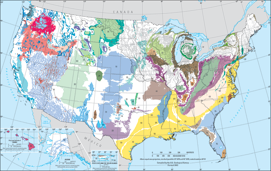
An aquifer is an underground layer of permeable rock, sediment, or soil that holds groundwater in the spaces between particles or within fractures and that allows that water to move. The U.S. Geological Survey (USGS) has identified 62 named principal aquifer systems across the conterminous United States, covering a substantial portion of the country. Hundreds of smaller, local aquifer systems exist beyond those mapped at the national scale.
For geothermal heating and cooling, aquifers matter because groundwater is a dramatically more effective thermal exchange medium than solid soil or rock. Water conducts and carries heat roughly 25 times more effectively than dry soil. A well drilled into a productive aquifer can access this moving water, run it through a heat exchanger to transfer thermal energy to or from a building, and reinject the water back into the aquifer, returning it to the ground essentially unchanged except for a small temperature differential that equilibrates quickly.
This is the mechanism behind Darcy’s groundwater-based geothermal approach. When a productive aquifer exists beneath a site, accessing it unlocks a level of thermal capacity per well that closed-loop borehole systems simply cannot match. A productive aquifer well can deliver 50 to 200-plus tons of heating and cooling capacity from a single Darcy well. The equivalent closed-loop borehole field for that same load might require 100 or more individual boreholes spread across a large surface footprint.
Not every site has an accessible aquifer. Some locations sit atop low-permeability bedrock with little or no viable groundwater. Others have aquifers too deep, too saline, or too low in yield to support a commercial geothermal system. That is precisely why geology is the starting point for every Darcy project.
The Main Aquifer Types and What They Mean for Geothermal
Aquifers come in a range of types, each with distinct characteristics that affect how suitable they are for geothermal thermal exchange. The USGS classifies principal aquifers into six lithologic categories based on the type of material that stores and transmits groundwater. Here are the types most relevant to commercial geothermal applications.
Unconsolidated Sand and Gravel Aquifers
These are among the most productive and geothermal-friendly aquifer types in the United States. Sand and gravel aquifers form in river valleys, glacial outwash plains, and coastal plains where water-deposited sediments have created thick, highly permeable layers. The Midwest, upper Great Plains, and portions of the Northeast overlie extensive sand and gravel aquifer systems deposited by glacial activity during the last ice age. The high permeability of these materials means that wells drilled into them can yield large volumes of groundwater at relatively shallow depths, making them excellent candidates for the pump-and-reinject geothermal configurations Darcy engineers.
Carbonate Rock Aquifers
Limestone and dolomite aquifers, sometimes called karst aquifers, are characterized by secondary porosity created by the dissolution of calcium carbonate over geologic time. Water moving through these rocks gradually enlarges fractures and bedding planes into conduits that can transmit groundwater rapidly and in large volumes. The Floridan Aquifer System (covering most of Florida and parts of Georgia, South Carolina, and Alabama) and the Edwards Aquifer in Texas are among the most productive carbonate aquifers in the country. Karst aquifers can support high-yield geothermal wells, though their heterogeneity can make predicting well yield more challenging than in homogeneous sand and gravel systems.
Sandstone Aquifers
Consolidated sandstone aquifers underlie large portions of the Midwest, the Great Plains, and the Appalachian region. Their permeability is generally lower than unconsolidated sand and gravel systems, but many sandstone units are thick, laterally extensive, and capable of supporting moderate groundwater yields at depth. The Mount Simon Sandstone beneath the upper Midwest is one example of a deep, regional sandstone unit that serves as a groundwater source across multiple states. Geothermal viability in sandstone aquifers depends heavily on local yield and water quality.
Fractured Crystalline Rock
In regions where crystalline bedrock (e.g., granite, gneiss, schist) is at or near the surface, groundwater occurs primarily within fractures rather than in pore spaces between grains. Fractured crystalline rock aquifers are common in New England, the upper Midwest, and the Rocky Mountain foothills. Yields from fractured bedrock wells are often lower and more variable than from sedimentary aquifers, which can constrain the geothermal capacity available from a single well. In these settings, closed-loop borehole systems are often the more practical choice, though favorable fracture zones can support groundwater-based approaches in some locations.
Glacial Deposits and Buried Valleys
Across the Midwest and upper Midwest, repeated glaciation over the past two million years deposited thick sequences of sand and gravel outwash in river valleys and between till units. These buried valley aquifers are often highly productive and exist in close proximity to the dense urban and suburban areas where commercial geothermal demand is strongest. Minnesota, Wisconsin, Illinois, Indiana, Ohio, and much of the Great Lakes region sit atop geologies that are particularly well-suited for groundwater-based geothermal systems.
What Makes an Aquifer Productive for Geothermal Thermal Exchange?
Not all aquifers are equally useful for geothermal applications. Even within a region with good groundwater resources, individual sites can vary significantly. Darcy’s geology team evaluates several key characteristics when assessing a site, detailed below.
Hydraulic Conductivity and Well Yield
Hydraulic conductivity is a measure of how easily water flows through the aquifer material. High hydraulic conductivity means the aquifer can supply water to a well quickly and in large volumes. Well yield, typically measured in gallons per minute (gpm), is the practical expression of this in a drilling context. For a commercial geothermal system, well yield is directly tied to thermal capacity. A well yielding 300 gpm in favorable temperature conditions can support a very large geothermal system. A well yielding 20 gpm is better suited to a smaller application or a closed-loop approach.
Aquifer Thickness and Depth
Thicker aquifer units generally support higher yields and provide more thermal exchange volume. Depth matters for both practical and regulatory reasons. Shallower aquifers are less expensive to drill and may fall under simpler permitting regimes, while deeper aquifers may require more complex well construction but offer access to groundwater that hasn’t been influenced by surface conditions. For most commercial geothermal applications, Darcy targets aquifer systems accessible within a few hundred feet of the surface, though the optimal depth range varies by geology and system design.
Confined vs. Unconfined Aquifers
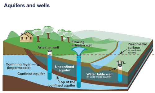
A confined aquifer is one bounded above by a low-permeability layer (a confining unit or aquitard) that restricts the upward movement of water. Pressure in a confined aquifer often exceeds atmospheric pressure, meaning water in a well may rise above the top of the aquifer and sometimes to or above the ground surface (artesian conditions). Confined aquifers are often well-protected from surface contamination and tend to maintain more stable temperatures. Unconfined aquifers, also called water table aquifers, have a free water surface at atmospheric pressure and are more susceptible to surface influences. Both types can support geothermal systems, but confined aquifers often present advantages for water quality and thermal stability.
Groundwater Temperature
Groundwater temperature in most U.S. aquifers closely tracks the mean annual air temperature of the region, typically ranging from 45–65°F across the continental United States, annually varying only by a few degrees at any given location. This natural temperature stability is one of the fundamental assets of groundwater-based geothermal systems. Warmer groundwater temperatures favor cooling-season performance, while cooler temperatures favor heating performance. In practice, the moderate, stable temperatures found in aquifers across most of the U.S. are well-suited to year-round commercial HVAC applications.
Groundwater Chemistry and Scaling Potential
The chemical composition of groundwater affects equipment selection, heat exchanger design, and long-term system maintenance. Water with high iron content, elevated hardness, or high total dissolved solids can cause scaling or corrosion in heat exchangers and piping if not properly accounted for in the design. Darcy’s assessment process includes groundwater chemistry analysis for sites where chemistry data is not already available from existing well records. Understanding the chemistry early in the project is essential for specifying the right equipment and avoiding maintenance issues that would not otherwise be anticipated.
How Darcy Evaluates a Site: From Desktop Study to Design Well
Darcy’s site assessment process is built around the reality that no two sites are the same. The goal at each stage is to reduce uncertainty about subsurface conditions before committing significant resources to the next phase of work.
Geologic Desktop Evaluation
The first step for any potential project is a desktop geologic evaluation conducted by one of Darcy’s Professional Geologists. Using published geologic maps, well log databases maintained by state geological surveys and the USGS, existing groundwater study reports, and Darcy’s own database of well and project data accumulated over years of work across the country, the geology team builds an initial picture of the subsurface at a given location. This includes identifying the likely aquifer units present, estimating their depth and thickness, reviewing groundwater yield data from nearby wells, and assessing groundwater chemistry based on available records.
The output is a clear professional recommendation. Either the site is a strong candidate for a groundwater-based system, it warrants further investigation, or the geology suggests a closed-loop approach would be more appropriate. This assessment is provided at no cost as the first step in Darcy’s project engagement process. For most sites, Darcy can deliver an initial geological picture within a week or two of receiving the address or site coordinates.
State and Federal Data Resources
One of the advantages of working with a dedicated geology team rather than a generalist engineering firm is deep familiarity with the groundwater data resources that inform these assessments. State geological surveys across the country maintain well log databases, aquifer characterization studies, and groundwater monitoring datasets that provide a rich subsurface picture for most populated areas of the United States. The USGS National Water Information System (NWIS) provides access to water level, water quality, and streamflow data from tens of thousands of monitoring wells nationwide. The USGS Ground Water Atlas of the United States remains the foundational national reference for aquifer extent and characteristics.
For sites in areas where Darcy has previously completed projects or assessments, proprietary well data from those projects further refines the subsurface picture. This accumulated dataset is one of the operational assets that distinguishes Darcy’s geological assessment from what a typical HVAC or mechanical contractor can offer.
On-Site Investigation and Design Well Program
When the desktop evaluation identifies a site as a viable candidate and the project team is ready to proceed, on-site investigation confirms and quantifies the aquifer’s characteristics. For groundwater-based systems, this typically involves drilling and testing a design well, where a borehole is drilled to the target aquifer zone, logged for subsurface conditions, and pump-tested to measure yield, drawdown, stratigraphy, geophysical data, and requirements for construction. Water samples collected during testing characterize the groundwater chemistry, while temperature profiling confirms the thermal resource characteristics at depth.
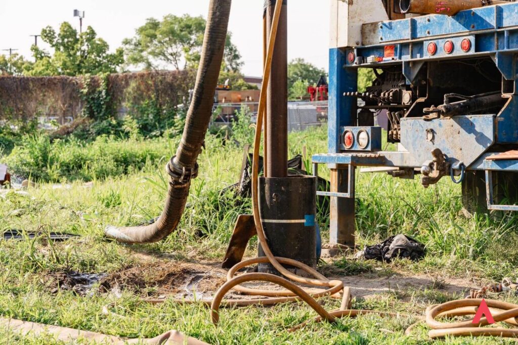
The design well program produces the data Darcy needs to finalize system design with confidence, specifying well count, depth, spacing, pump capacity, and heat exchanger configuration based on measured site conditions rather than regional averages. It also provides the documentation required for well construction permits and any required groundwater appropriation or injection approvals.
Where Does Geothermal Work Best in the United States?
While every site requires individual assessment, regional geology provides a useful starting frame. Several broad geologic settings across the United States are particularly well-suited for groundwater-based commercial geothermal:
- The Midwest and Upper Great Plains: Thick glacial sand and gravel deposits overlie marine sedimentary bedrock in much of Minnesota, Wisconsin, Iowa, Illinois, Indiana, Michigan, and Ohio, supporting productive aquifer systems at relatively shallow depths. This is Darcy’s home market, and the geology here is among the most favorable for commercial groundwater-based geothermal in the country.
- The Mid-Atlantic and Northeast: Coastal plain sediments along the Atlantic seaboard and thick sand and gravel deposits in river valleys across the region support productive aquifers in many areas, though fractured bedrock at or near the surface in parts of New England favors closed-loop approaches in those specific areas.
- The Southeast: The Floridan Aquifer System is one of the most productive aquifer systems in the world, supplying groundwater across Florida and portions of surrounding states. The surficial aquifer system in Florida also provides significant groundwater resources at shallow depth.
- The South-Central United States: The Edwards Aquifer in Texas and the Mississippi River Valley alluvial aquifer system both provide strong groundwater resources in portions of their areas.
- The West: The alluvial basins of the intermountain West, including in Arizona, Nevada, and California’s Central Valley, contain significant groundwater resources, though water rights and regulatory considerations vary considerably by state and region.
Absence from this list does not mean absence of geothermal potential. Many areas underlain by fractured bedrock, moderate-yield sandstone, or localized sand and gravel deposits can support closed-loop geothermal systems with excellent performance. The geology informs the system design; it rarely eliminates the possibility of geothermal entirely.
Start with the Geology
The single most valuable thing a project team can do early in the evaluation of geothermal for a given site is to get a professional geological opinion on what’s underneath the site. That opinion doesn’t require a drilling program or a significant capital commitment. It requires the site address and a geologist who knows how to read the regional subsurface picture.
Darcy’s site assessment is that starting point. It’s free, it’s conducted by a licensed Professional Geologist, and it typically delivers an initial recommendation within one to two weeks. For projects that advance, the desktop assessment becomes the foundation for every subsequent phase of the work, from design well to final system engineering.
If you’re evaluating geothermal for a building or campus and haven’t yet looked at the geology, that’s the right place to start.